Friday, February 10, 2006

....part 6 conclusion...

Day 3:

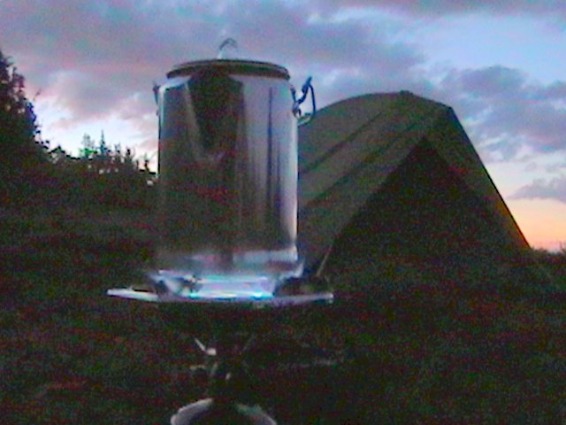
Morning came with a crisp coolness in the mountain air. I put on a coffee pot for hot water before most of our crew was out of their sleeping bags. The sun was rising and it looked like it would be another great day for hiking. I woke Andrew and told him we needed to break camp and have breakfast. He dressed and had a hot breakfast. It wasn’t long before we discussed the day’s hike, said a prayer and began our assent to the Coyote Trail trailhead.

It had already been decided that Brian and Josha would go ahead of us, because they were faster hikers, to go get the second vehicle and meet us at the trailhead when we came in. They were eager to make the hike at their own pace and were soon out of sight. We all had maps and trail instructions so there shouldn’t be a problem…or so we thought.

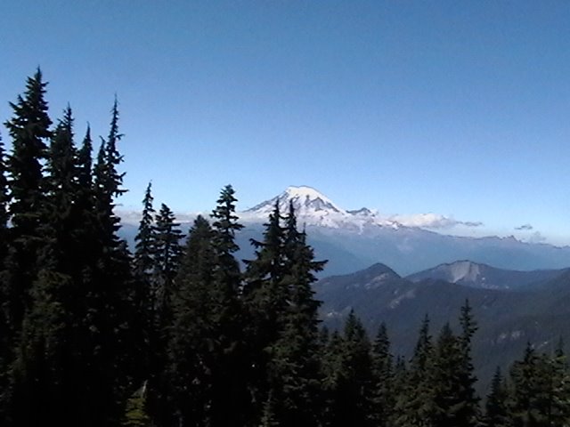
We stopped at the Coyote Trail trailhead to take some early morning photographs. The sun was shining from the eastern sky which made the haze disappear, brightening up the snow dotted mountainsides and the grassy valley below. I failed to notice Andrew dropping off down Coyote Trail alone, probably 15 minutes before we would be ready to go. It would be a couple of miles until I could get within shouting distance and stop his hiking. He knew better than to hike alone. We talked about it before. It would be only natural for a Cougar to roam this area looking for young goats or Marmot to make his dinner. I only hoped that would not be Andrew!

This side of the mountain is home to many Goat, Elk and Deer. Two years ago I counted a herd of over 60 Elk standing or lying down on a large snowfield across the valley to the other side. We watched herds of goats roaming the valley floor below, grazing on the lush grass and wild flowers. This area is primitive and protected by a barely accessible valley and high mountains on three sides. The valley floor is heavily wooded, providing protection for a dozen herds. If a predator or human on horseback approached a herd, the goats or elk could easily escape because of their great agility and endless strength.

I was finally able to get Andrew’s attention so he would stop. The trail down the steep mountainside had a large clearing with many switchbacks. It was in that area that Andrew finally heard my now scratchy voice and stopped on the trail. Thoughts of “killing him”, or leaving him in this wilderness, and other things danced in and out of my mind like channel surfing on TV. It was probably good that the trail was long. I managed to be calm, but stern, as I reminded him that his Mom entrusted him to me and that it was my responsibility to get him home in one piece. I told him about the Cougars in these woods and he wasn’t ready to be Cougar food. He was great the remainder of the trip.

We came to a fork in the trail that was not on our map. Looking on the ground we saw an arrow fashioned from 3 sticks pointing to the left trail. It did not look well traveled but thoughts of our conversation with a couple we met at the PCT trail marker the day before in Snowgrass Flats came to mind. They reminded us to watch carefully for the trail to Packwood Lake as it left the Coyote Trail, that it was hard to see. Perhaps this was it. We believed the arrow was left by Brian and Josha to make sure we didn’t miss the junction. Some of our group was still a ways behind us; Pat, Shannon and Marvin were behind me because I had “hot footed” it down the trail in order to catch up with Andrew. We waited on them to catch up with us before we continued.

As we all gathered together and discussed this particular part of the trail, pausing for a drink of cold water and trail food, we heard a noise. Turning, we saw Brian and Josha coming back up the trail towards us at a brisk pace. They told a story of how the trail sort of disappeared in the growth of brush and grass, appearing to turn back up towards Old Snowy. I checked my GPS with the coordinates on the map and there was a discrepancy. We decided to stay on Coyote Trail and see where that takes us.

It wasn’t far until we came to a well marked trailhead that showed us the Packwood Lake Trail very clearly. We knew we had made the right decision. At that point, Brian and Josha took off again at a brisk pace to jockey the vehicles at the end of our trail. The rest of us “old codgers” and young guys continued at a much slower pace now. Our knees were in pain from the steep downhill hiking; pounding our joints with every step. Even Shannon and Chris, the two young guys were in bad shape. I think Pat, Marvin and I were in better shape then them.

A few stops and some fresh water; a few snacks and a good rest and we were ready to resume. Shannon was getting frustrated because we didn’t know how far it was to the end of the trail. I took another GPS reading, checked the map and found out we were 2 miles from Packwood Lake; that the lake was 2 miles long; and that the remainder of the way was 4 miles. I had told the men that today would be a 12 mile trip. It is.

Packwood Lake was beautiful. The water was clear and clean, barely touched by anyone. Ducks swam on the water and fish darted into the shadows. We began to come near people who were tent camping along the lake and the smell of campfires filled the air. We stopped for a minute as Marvin wanted to use a rustic outhouse.

At the end of the lake a man approached us and talked about Chris and Andrew, who had hiked on ahead of us, that they had taken the ATV road to the parking lot instead of the foot trail. We decided to do the same. The kind gentleman walked with us for a ways and showed us the way to go.

We began to increase our pace on the road in order to catch up with our crew. Soon we found Chris and Andrew, energy spent, waiting on us in a small clearing. We didn’t stop; kept on walking at a brisk pace, as they followed behind. Soon we spotted the tops of parked cars and knew this was the end of the trail. We scrambled up a steep slope to shorten the way around and found ourselves looking out on a parking lot filled with cars, belonging to other hikers and campers. We spotted our van and car and quickly made our way. The doors were locked except for the back van door.

Opening the door we found a cooler filled with crushed ice and cold soft drinks. We dropped our packs and helped ourselves to the refreshing drinks, wondering where Brian and Josha were. We assumed they had grown tired waiting for us and had taken off down the trail to catch up with us. Unfortunately for them we did not take the trail so they would not find us.

Soon Brian and Josha appeared at the trailhead telling us that they thought we might have taken the road, so they turned around and jogged back.

We had a good laugh from the whole event and talked about everything. As we loaded up and drove away, visions of large Burgers and Fries filled our thoughts. We were ready for home. Our bodies felt like they were beaten to a pulp and our brains fried from all that fresh mountain air. We wondered why we had taken such a hard trip of 30 miles. Marvin, Shannon and Chris were very glad to get back home and to know that it was all over.

Pat and I, hurting though we were, began thinking of our next backpacking adventure with Brian, Andrew and Josha. …..it’s going to be great!

Thursday, February 09, 2006


...Page 5
Stepping into the snow was exciting. To reach down and touch it or to kick it with the toe of our boots, sending a spray of ice upon each other was refreshing. The snow was heavily packed and became more and more like hard, crusty ice. We were following tracks previously left by another hiker. These tracks led us to a very icy patch at a much steeper place than we liked. It was there that we decided to sit down and slide the 10 or 12 feet to the rocks below instead of side stepping a hundred feet or so uphill and going around the steep places.

Brian was the first to go sliding. Short of wet pants, it was a quick way down to pick up our trail in the rocks below. With his help, stopping us before we crashed into the rocks, we each slid down the icy bank, one after another. Our shorts were soaked and stuffed like a snow cone, but it felt good.

Knowing that we needed water, we still hiked to the top of the saddle before dropping our packs. Topping the saddle we were provided vistas of the magnificent Mt Rainier to the north, Mt Adams to the south and Mt St. Helens to the west. Ives Peak obscured the view of Mt. Hood.

The melting snow on the north face of Old Snowy Mountain roared down across Packwood Glacier and spilled into the deep valley and flowed into Packwood Lake.

It felt good to drop our heavy packs. Brian, Josha, Chris and Shannon volunteered to fill our water bottles. I gave up my water filter to help with the process. Andrew, Marvin and I stayed behind as the flour young people scurried down the rocks to the pool of cold snow melt two hundred feet away. As Marvin and I dropped to the ground to lay against our packs, snacking on trail food, we talked about how important our job was to stay behind and guard the packs. This way, we felt justified in staying behind.

Soon the young folks came back up the rock hill, handing us cold water that tasted much better than “good”. After a few snacks and a short rest, we donned our packs to resume our trip.

It was mid-afternoon when we dropped off of the Old Snowy saddle and onto the upper side of the area known as Packwood Glacier.

In 1996 when Marvin and I led the Boy Scouts across this area, the glacier was very prominent. In fact, we had to be very careful to hike across the hard ice field then. We used a 50’ rope to help us stay together and positioned an adult leader as an anchor point in case someone slipped. It would have been a very fast and deadly ride to the valley below. But today the glacier has melted down and exposed rocks, over which we had to walk. The high, rocky peaks to our upper side towered above us.

We were inching our way across the ever moving rocks on a very steep slope. Andrew had listened to my lecture of being very cautious and was making certain to plant his feet on those spots less likely to slide out from under him.

We were perhaps 500 yards from the saddle when a rock slide occurred at a place we had just been walking, barely ten minutes ago. I thought about what might happen if a rock slide would occur where we were standing. It wasn’t a pretty picture because there would be no place to hide and running was not an option.

We crossed another hard packed snow field, the last of the snow we would touch on this trip. It was steeper than the last snow field and more frozen because of the strong wind that blows from the valley across the mountain face.

The sun was getting low in the western sky. We still had two or three miles of knife edge trail to hike. The trail was very narrow in this area because it crossed the very top of the mountain peaks. As treacherous as it was, it provided awesome views of Mt Rainier, Packwood Lake and wild Mountain Goats. We stopped often to snap photos of the big shaggy goats running down hill, stirring up dust clouds and kicking rocks. We watched as they grazed on the wild vegetation growing sparsely out of the dry volcanic soil or out of the rocks themselves. We viewed herds of wild goats in the Packwood Valley to the left and in the McCall Glacier Basin to the right, on a trail barely 5 feet wide; even narrower in many places. One trail marker warned riders that there was no place to pass another horse, or hiker, for a distance of ¼ mile.

All of us were getting tired when we came to a trail marker that identified the trail we would be taking tomorrow on our last day. It was called Coyote Trail, perhaps because it took off of the PCT at an angle that only a Coyote could do!

From this vantage point, we could turn around and see our campsite a mile away and below us. I pointed out to our crew the campsite and they gained a renewed energy just knowing we were close to a stopping place in today’s long day’s hike.

Shannon was like the tired horse that got a whiff of the barn. He lit out like a Jack Rabbit; like he had a purpose. We all followed close behind him. We stopped occasionally to snap photos and watch the evening sun cast a golden blow on the snowfields and glaciers of Mt Rainier.

Soon we were dropping our packs and selecting our tent sites. This was a large flat area called Elk Pass and the only place within miles that connected one valley to another. It was said to have been discovered by a herdsman several years ago looking for a way to go across the mountains with his herd.

This was the same area that Doug, Eric and I had watched a Black Bear forage on food as we backpacked from the north into the Elk Pass area. I wasn’t going to tell this bear story to my fellow hikers, however. I didn’t want them lying awake half the night wondering if they would be bear food or not. So I managed to keep that story to myself.

After setting up camp we took off down the hill to find water. It was quite a ways off but we managed. Two years ago this area was plentiful with water. Snowfields dotted the trail and the sound of rushing water from the snow melt was deafening. The flowers were bright and colorful; the entire Pass looked alive. This year, however, there were few flowers and the water was not in abundance. There was only a trickle of water on this particular evening as we searched for small pools of running water to fill our water bottles for tonight’s cooking and tomorrow’s coffee.

It was dark when we sat down to eat a hot meal. I was almost too tired to eat but managed to do my best. All of us needed the hot food to re-energize our strength. Even Andrew had run out of energy and was in bed before I knew it. He was asleep in minutes. I think I was, too.

I had a restless night, often waking to the sounds of unknown noises. The wind was gusty and the night sky was clear. At one time, I awoke and unzipped the tent so I could look at the stars. They were brilliant! A magnificent masterpiece of God’s imagination! I could not remember ever seeing this many stars before at one time. There were many “shooting stars” this night; so beautiful to watch.

....to be continued

Monday, February 06, 2006

Page 4....

The next morning was crisp and heavy fog filled the valleys below us like snow. Heart Lake was mirroring the fog and the high mountains in the still morning air. We sat around sipping our morning coffee taking in every sight. I talked to Josha about letting Andrew sleep in her tent, so he wouldn’t have to carry the extra weight. She was glad to do that. Shannon would take the tent that he and Marvin stayed in. Chris would bunk in with Brian. Pat would have his tent and Marvin could move in with me. It was settled.

Brian and Shannon walked back down the trail to refill water bottles and canteens. They came back into camp and told us about “Plan B”. They suggest that they could carry some of our gear. A lighter load would take excess strain off our knees and joints, then see if we could all continue on together and see how we fare. I was in agreement with that plan and asked Marvin what he thought. He said it might work and was willing to try it as far as Goat Ridge, the next mountain range east, about 2 miles distance. We quickly packed our gear and divided the weight. Brian carried my tent and Shannon carried Marvin’s food and some other weight. Thus we began day two of our trip.

Today was supposed to start from Goat Ridge and end up at Elk Pass. Today would be the most strenuous and most scenic day of all. We were already two hours and two miles behind schedule but focused on what we needed to do. In a couple of hours we were on top of Goat Ridge looking down into the next valley towards Snowgrass Flats. We stopped for a snack and photo shoot before proceeding on the descending trail towards Goat Lake.

As we old guys in the rear approached Goat Lake, we noticed the younger “trail burners” were already on the shore dropping their packs and starting to rest. I had my DV Camera out and was filming when we noticed someone was swimming in the lake…..it was Josha! The next thing we knew Brian waded out into the cold water and dove in like he was doing the Fosberry Flop, or something! I did manage to catch it on film before it forever disappeared into the mountains of Goosebumps and shivers.

Goat Lake is normally frozen over this time of the year because of the heavy snowfalls these mountains get during the severe winters. This is the second year I’ve seen the lake thawed out. Like before, the water was the color of a light shade of Army Green. This is apparently caused by the color of the rocks under the water. There was still a lone patch of snow on the opposite bank, indicating the water temperature was still in the 40’s. I yelled out to ask Brian if the water was cold. He replied, “About 20 degrees”! Indeed it was as I dropped my pack, removed my socks and walked out into the freezing liquid of green.

I was not about to take a swim like Brian and Josha but I did like the feel of the cold water on my aching feet. Shannon and Andrew said they couldn’t handle the cold water and choose to remain on the bank. It wasn’t until we were filling our canteens through my water filter that I noticed Shannon taking off his boots to try the water. He said he couldn’t justify coming all this way and not do something out of his comfort zone.

There were no snowfields between Goat Lake and Snowgrass Flats like many years before, and water was not as plentiful along the trail, yet it was enjoyable in its own way. It brought back many memories as we hiked. At Snowgrass Flats we turned and saw the trail marker that identified this end of the Lily Basin Trailhead. Now I will not need to imagine what that trail looks like or where it goes. I will do that one again someday.

After a brief rest, we made our way uphill towards the top of Old Snowy Mountain. We would have a hard climb ahead of us for the next 5 or 6 hours. The trail soon emerged from the last of the trees and connected with the Pacific Crest Trail 2000. Marvin and I stopped and recalled our trip of ’96 with the Boy Scouts. I pointed out the spot where we had made camp that night and where I have camped several times since then. He was glad to be here. He was still doing good and not complaining, although I know he was hurting and being tested. Chris and Shannon’s knees were beginning to hurt. Pat and I had our aches and pains but we were doing much better than we had on previous hikes. Towards the north we could see the saddle of Old Snowy Mountain, where we needed to be before mid afternoon.

Standing beside the weather worn trail marker identifying the Pacific Crest Trail, thoughts of other past hiking adventures to this very spot filled my mind. The area seems to change with each passing hike into these mountains. The wildflowers of every color, type and shape fill this rich volcanic soil as with an artists’ brush. Ever moving, ever changing, every year is different.

Today I notice the area is overly dry and the wildflowers have withered and died, waiting for water that failed to come. The stream beds were dry. This was evidence that last winter was drier than normal and the snowfall was less than what was needed to sustain the meadows through the dry months of July and August.

We began our trek, ever climbing towards Old Snowy. We stopped to rest, more frequently now because we grew weary of today’s workout. We paused near the last grove of weather beaten evergreen trees to answer the call of nature; girls to the left; boys to the right.

As we approached Old Snowy, we caught a view of Goat Lake off to the left in the distance. We were amazed that we had traveled this far in that short amount of time. Our minds retraced our steps from Goat Lake, recalling the bravery of those who chose to take a plunge into its icy waters. I took notice that the long waterfall descending from the overflowing lake into the beautiful valley below was virtually non-existent this year; more evidence of last year’s snowfall.

As we topped the last rise for a view of the Old Snowy saddle, our respite from the grueling uphill, to which we have become so familiar, our eyes came to rest upon an enormous snowfield. So this was the hiding place of our next drink of cold water. This was the place where our sunglasses would come in very handy.

.....to be continued.....

Friday, February 03, 2006


Page 3..........

There were 8 of us packing together today.

Brian, my good friend from church, a professor of Bible at Cascade College, who holds a Doctorate Degree and one of the most highly respected men I know, is an avid hiker who often goes with me on these mountain adventures. This will be Brian’s 4th or 5th trip into the Goat Rocks.

Andrew, the only minor in our group is my “grandson of the heart”, a great young man who enjoys the mountains and the adventures of the trek. He has been going with me here for 3 years, having grown to be a strong hiker and fun to be with. He loves the mountains and the August snow.

Josha, the only female on this trek is a young lady who is studying to be a physical therapist and wants to work with kids some day. She also holds a degree from Cascade College. (I must admit, I enjoy hanging out with “smart” people). She is like a daughter to me and loves the mountains. She is a marathon runner and loves backpacking. This will be her 3rd trip into these mountains.

Pat, my brother two years younger, has discovered backpacking and enjoys the high mountains like me. This will be his 4th trip into this area. Pat lives in Oklahoma. Besides his day job in a fabrication shop as an inspector supervisor, he owns a Pecan farm on old Route 66, outside of Vinita. He loves to fly out and hike with me at every opportunity. Pat has been having knee joint problems and is uncertain about this trip.

Chris, Pat’s son, is a first time backpacker. He also lives in Oklahoma, works in an industrial shop as a supervisor and believes he is in good enough condition to do this hike. He, like the rest of us, is completely unaware of how physically demanding this trek is going to place upon him.

Marvin, my brother-in-law has flown out from Missouri to go with me on this trip. He owns a campground on the huge Lake of the Ozarks but has found the time to slip away from his busy August season to take this trek. Marvin was my co-leader when we brought my Boy Scouts of Troop 49 across 70 miles of the William O. Douglas Wilderness and the Goat Rocks Wilderness in 1996. It was our first time to view this magnificent scenery as we hiked the Pacific Crest Trail 2000 for 11 days between Cayuse Pass and Walupt Lake, Washington. Marvin had heart surgery last year. Although his heart doctor says he is stronger than ever, he feels a little apprehensive about putting too much stress upon his newly repaired heart.

Shannon, Marvin’s son-in-law, is also a first time packer, but is very anxious to get started. He is a hard worker who has his own trash hauling and clean-up business in Missouri, who feels strong and in good shape for this trek. Shannon is also there to keep an eye on “Dad” just in case there is a problem. This will be a good bonding time for them, as well.

I make up the 8th part of this group. My name is Mike. I work for a Mechanical Contractor as a Service Manager and small projects manager. This will be my 9th year to backpack into this wilderness area since Marvin and I discovered it in 1996. The draw of these mountains is nothing I really understand. Each year it changes and I discover something new and different. I also enjoy sharing it with others by bringing people into this area who have never seen it before. Besides the scenic mountains and a myriad of wild flowers that seem to scratch a short life out of a dry, rocky outcropping, or thrive in lush spring fed meadows, we have viewed wildlife of Elk, Deer, Bear, Shaggy Goats, Marmot, Pica, and birds of all kinds. The scene is ever changing from frozen lakes; snow in the campsites, crossing snowfields and glaciers, hailstorms, rain to hot and dry and looking for that next stream to refill our canteens.

None of us have ever hiked the Lily Basin Trail even though we’ve often passed the trail marker at Snowgrass Flats. This day will be a new treat for all of us. The trail takes us ever upwards, through dense forests of Douglas fir, Red Cedar and shrubs of all kinds. The trail appears to be drier than I had thought, but we still carried plenty of water with us. It was not a steep trail, yet it climbed steadily upward. We enjoyed occasional views of the magnificent Mt. Rainier and Packwood Lake as the trail meandered along the tops and north faces of little known mountains. Along the other side of Packwood Lake is the trail we will be coming down on our last day. It seems so near, yet far away at the same time.

As we topped one of the summits our trail intersected with Angry Mountain Trail and we began to catch our first glimpse of patches of snow in the higher mountains. We began to emerge from the heavier forests and into patches of smaller shrubs, grass and fields of flowers. We occasionally passed a wetland where yellow and white flowers thrived with the beautiful Indian Paint Brush flowers of brilliant colors, more brilliant than I had ever seen before. I couldn’t take enough pictures. Every other one looked more colorful than the one before. Small Bumble Bees swarmed the bright yellow flowers franticly, as if this was the last day they could collect the sweet nectar.

Pat, Marvin, Shannon and I took it easy hiking this trail so as not to tax Marvin’s body too much. We all kept an eye on him, ready to retreat at the first sign of difficulty. Shannon was like a mother hen watching over her brood, instinctively protective, ready for anything out of the ordinary. He still managed to breathe in the freshness of the mountains and bask in the awesome views of the glaciers on Mt. Rainier, to the island in the middle of Packwood Lake. He was having the time of his life. Brian, Andrew, Josha and Chris were yards ahead of us and would occasionally stop to let us catch up with them. It was obvious that they were much stronger hikers and we were slowing them up. I think we were taking too many pictures and that slowed us up more than our age. At one place where they waited on us, we approached and began taking in the scenery as we rested a moment. We looked down into the grass and watched a large Mole dig his way in and out of the hillside.

We snacked on trail food along the way, so we had no official stop for lunch. Towards the late afternoon the steady climb of the trail was wearing on our knees and the thinner air taxed our breathing. We still had not crossed any streams or found any springs of water to refill our canteens.

A few miles later, we rounded the trail only to find the leaders waiting on us at a trail intersection. As we approached, Brian told us that this intersection was not on the map and was wondering which trail we take. The right fork wandered off downhill into a valley, while the left fork continued along the hillside towards a ridge. I suggested we take the left fork because we had to cross that ridge. If we went down into the valley we would have to come back up again and that would take extra work. I wasn’t certain how much farther we had to go to reach Goat Ridge, which would be our camping site for the first night. The problem became clear. Clouds were dropping down off the surrounding mountains at an alarming rate. I wasn’t sure what it was all about unless it was a storm approaching. The temperature was dropping and the sun had settled down behind the mountains. There might not be too much more daylight if the clouds continue to come in and cover the trail. Besides that, we might not want to be camping on a high ridgeline if a storm was approaching.

After an hour or so, we came upon a stream where we refilled our canteens and water bottles with fresh clear water that we ran through our water filter. As we came out of the ravine where the stream flowed down the mountain, it became quite clear that the weather was changing for the worse. I wished that half our crew would stop and wait on us to catch up because we might need to make other plans for the night. Shannon said he could run on ahead and catch up with them if I wanted. I told him to go ahead and have them wait on us and perhaps take the next available campsite for ourselves. It turned out that they were only ahead of us a hundred yards or so and was waiting on us in an available campsite. We decided to stop there and camp for the night. We can’t be more than a couple of miles from where we would be camping anyway. Besides that, we had a magnificent view of the mountains, patches of snow, and Heart Lake down into the valley below us. Now we understood where that right fork of the trail descended to.

We began taking off our packs and locating our tent spaces. We noticed a herd of about 30 big shaggy Goats grazing above us on the side of the mountain. It was a beautiful sight. Soon the tents were up and the cook stoves were boiling water, getting ready for the evening’s meal. It was getting colder and the wind was picking up. Andrew came over and was shivering in his T-shirt. I asked if he had a jacket and he told me he had left it in the car. Lucky for him that Brian had an extra jacket which he lent to Andrew. The fog continued to roll in like smoke from a forest fire.

Marvin looked tired. I went over to him and asked how he was doing. He said he was doing okay but very tired. I suggested that I would be okay with camping here for a night or two then turning back instead of continuing on to the planned end of the trek. I wanted to give Marvin the option of making the call so as not to make him feel like he was wimping out on the plan and causing all of us to miss out on the adventure. I would tell the others to go ahead as planned and we would meet them at the Packwood Lake trailhead in 2 days. Marvin thought that this was a good plan as long as I was okay about it. I assured him that I was.

I called a meeting of everyone and told them the situation. Pat said he would stay with me because he was feeling the pain, too, and wouldn’t mind a shorter trip. I suggested that Chris, Shannon, Brian, Josha and Andrew continue on because the scene ahead of them tomorrow would be more than awesome. Yes, it would be strenuous but well worth it. With half of us being strong hikers and half of us being old men, we were okay with this plan. Brian suggested we sleep on it, so we did.

........to be continued.........

Wednesday, February 01, 2006

Page 2....

The hour and a half drive to our first stop, breakfast at Spiffy’s Restaurant, gave us time to talk and remember some of the highlights of previous adventures. I was just telling about the time when I pulled my pack from the back end of our station wagon and then remembered that my water bottle was still at home in the refrigerator. About that time my wife called me on the cell phone to ask about a particular water bottle that she discovered sitting on the kitchen counter. I recognized the description. It was Andrew’s water bottle and pouch, one that I had bought him for a Christmas present. I told her not to worry about it because we could pick up another bottle of water at the next stop. As we joked about that, it dawned on my foggy brain that I was wearing sandals and had ran off leaving my hiking boots sitting in my bedroom. I quickly phoned my wife to have her confirm my dreaded suspicions. She did.

My wife, Debby, has always been one to look after my needs. I can’t remember a time when she had a selfish bone in her body. She caught onto my situation in an instant and wanted to bring my boots and Andrew’s water bottle to us. We decided to meet at Spiffy’s where we would be stopping for breakfast, anyway.

Just before we finished our breakfast, Debby arrived to save the day! It was at this moment that everyone in our group knew what I had done. It will be a week or so before they let me forget this incident. I suppose having fun at my expense helped pass the time as we hiked the trail to Snowy Mountain.

The remaining 90 minute drive to the trailhead was uneventful except for one thing. Marvin remembered that he had left his hat sitting on the floor beneath his chair in the restaurant. We would not be going back for a hat. We stopped at the Packwood Ranger Station to use the facilities and to ask about the trail conditions and any restrictions for camping or fires. We noticed Smokey Bear hats for sale in the gift shop, so he purchased one for $15.00. We also picked up a couple of nice maps of the wilderness area.

Passing Deer and Elk in the road, we arrived at the trailhead parking lot where we would be emerging the last day of our 3 day hike. We left a changed of clothes in the trunk of the car so we would have something clean and dry to change into on our last day, We knew we would be tired and sweaty when we arrived because we had to face a grueling 13 mile hike from Elk Pass that last day.

Loading into the 15 passenger van, we proceeded to drive to the north end of the Lily Basin Trailhead. With only one other vehicle at the trailhead we had our choice of parking. We filled out the Wilderness Hiking Permit and attached our copy to the outside of Andrew’s pack, in compliance with wilderness regulations. We hung the Parking Pass from our rear view mirror to allow us to park our vehicle for the duration without being ticked by the Rangers. We donned our hiking boots, taking more ribbing from my fellow hikers, and slipped into the heavy packs. Pausing for a prayer to our Maker, thanking Him for safety and the chance to see this beautiful place, we began pounding the dusty trail towards Lily Basin.

to be continued....

Statcounter

Followers